About Glen Elder Dam
Glen Elder Dam is a multiple purpose dam and reservoir constructed by the Bureau of Reclamation in Osborne and Mitchell Counties, on the Solomon River in north-central Kansas, just west of Glen Elder.
Glen Elder Dam and Waconda Lake, one of the key flood control features of the Kansas River Basin, provides a high degree of protection to the lower Solomon River Valley.
When operated in conjunction with other basin reservoirs it contributes effectively to the control of flooding on the lower Smokey Hill and Kansas Rivers.
In addition, provides and serves 21,000 acres of valley lands for irrigation and provides substantial municipal water supply, recreation, fish and wildlife conservation, and pollution abatement benefits. The principal features involved in the construction, of Glen Elder Dam are an earth-fill dam, embankment, dike, spillway, outlet works, and access, service and county roads.
|
Bushman Construction Company submitted the low bid of $13,647,291.00 for the project.
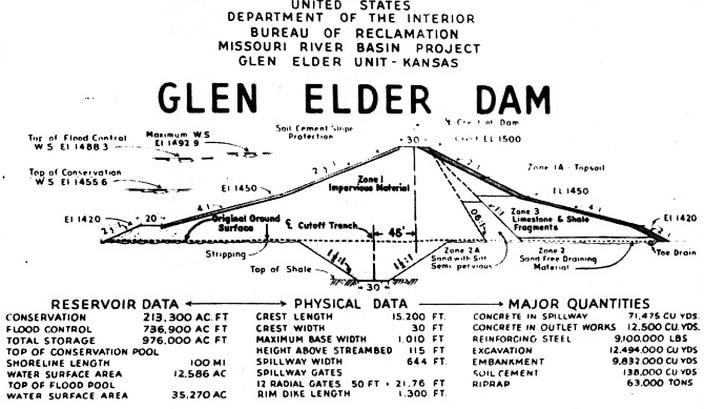
The dam was completed in December of 1968. It is 15,200 feet long with a maximum height of 115 feet above the Solomon River. A concrete spillway 644 feet wide controlled by 12 radial gates and separate river outlet works in a concrete conduit, 12 feet, 3 inches in diameter are incorporated in the structure. The crest of the dam is at elevation 1,500 and with water at elevation 1,488.3 the top of the flood pool. The dam has a storage capacity of 976,000 acre ft. |
|
Sufficient storage has been provided above the conservation pool to protect the valley below the dam from a flood equal in magnitude to the flood that occurred in 1951--the greatest recorded flood in the history of the Solomon Valley.
Waconda Lake, created by Glen Elder Dam, has a shoreline of over 100 miles and covers 12,586 acres at elevation 1455.6, the top of the irrigation or conservation pool. The conservation pool provides 213,300-acre feet of storage for municipal water and irrigation purposes. Presently (1970) 2,000 acre feet of this storage is allocated to the City of Beloit as a source of municipal water with the remaining storage planned for use in the development of approximately 21,000 acres of irrigated farm land.
In addition, many new forms and areas of recreation, for both area residents and visitors, have come about through the creation of Waconda Lake.